
Photography by Andy Goodson, Mitch Doll and Sean Hootz
April 20, 2017, Saskatchewan — It was morning when we pulled up to the Mountain Cabin Recreation Site on the northeast tip of the Pasquia Hills. Down the road, the Bainbridge River sloshed and spattered with water so brown, it was easier to imagine chocolate milk.
There were four of us including myself, Sean, Mitch and Steve, a new friend who had reached out to us last year about coming along for a trip. Steve had a wealth of knowledge and experience acquired through a lifetime of camping, and working as an outdoor educator and President of SaskOutdoors. Despite the qualifications, he was a humble guy that operated on a level of peaceful acceptance I wanted to steal by osmosis.
What brought us to Bainbridge River was the history of fossil discoveries and likelihood of dramatic topography. I read reports of massive shale outcrops and the existence of a Late Cretaceous bonebed — a layer of rock that was the presumed source of fossilized shark teeth, fish bones and bird remains found downstream. Sean had pored over satellite imagery and identified what appeared to be a mass wasting nine kilometres upriver, which would be a collapsed riverbank larger than we've ever seen. He was also in contact with a local source who informed him of an old mining prospector's cabin somewhere in the area.
We stepped out of the vehicle to make use of the outhouse before foregoing the luxury. The sky was grey and the air chill. While the southern prairie showed springtime revival, the northern forest was still a drab mess shaking off a thin layer of snow mold.

Mountain Cabin Recreation Site is located off Highway 9 at the northeast edge of the Pasquia Hills. (Goodson)
"Oh, there it is," Sean said, pointing across the valley to its western slope where there was a small dilapidated shack. The way it was described to him had given the impression of a greater challenge. This was a bit of a letdown since we were prepared for adventure à la Goonies.
With time to spare, we decided to check out the area and, of course, make our way to the cabin.
There were bright cloths wrapped around aspen trees surrounding the recreation site. Steve explained that they were left by First Nations groups who've come to pray. Unknown to me, I photographed the Ribbon Trees, which was forbidden due to their spiritual significance. I later deleted the photos, but was interested to learn that the cloths were meant to decay naturally over time.
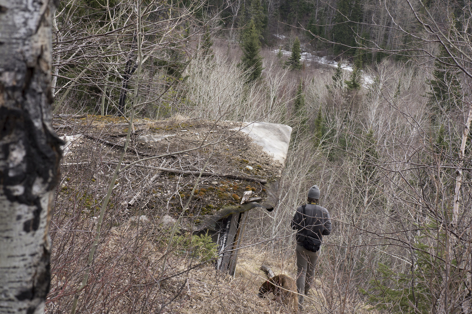
There were ATV trails that led us up to the old shack where we saw a glimpse of what was to come on our hike. The immense valley had snowy peaks giving off a mountainous appearance in contrast to the low-lying Saskatchewan River delta behind us.

High ridges at the Bainbridge River valley in north-east Pasquia Hills. (Goodson)

Closeup of the cabin — a bit more modern than expected. (Goodson)
View from Mountain Cabin (Goodson)
The shack was embedded into the face of a steep hillside just off the trail. Plexiglass windows, a furnace and some old beer cans meant that it was still used in some capacity. The roof, on the other hand, was returning to the earth quite nicely. After a short time we returned to the vehicles and began packing for a much longer hike.
Mitch was waiting at the treeline. "I guess here's as good a start as anywhere," he said before walking through a wall of tangled branches. The rest of us followed suit.

A bridge over Bainbridge (Goodson)

Sean experiencing the joys of bushwhacking (Doll)

Mitch – hard to miss with the red toque (Hootz)

Steve following behind on a bank of river debris (Hootz)
Branches whipped and cracked; the forest floor squished and snapped. The sweet scent of moss mixed with the pungency of balsam fir was more invigorating than a million gas station coffees.
We only got to the first riverbend before taking a short break—a half-kilometre in at best.
"Doesn't take long to remember why we don't bushwhack anymore," Sean said. Mitch and I joined in the complaining while Steve remained silent, checking out rocks and branches. I asked him if it was cool to take a break so soon. He seemed unfazed.
The river section ahead was covered in a thick sheet of ice that almost looked like a retreating glacier. There was clear meltwater trickling through large cracks and we could hear it percolating beneath our steps.
We took every chance we could to avoid bushwhacking, but fallen trees and riverbanks made it inevitable. Typically, we would walk through water. However, the weather forecast predicted rain and temperatures below zero for the weekend. Falling into cold spring runoff was not a risk worth entertaining.

"Bracket mushrooms" growing on a decomposing birch tree. (Goodson)

Large, round rocks such as this were found at Bainbridge River. We assume they are septarian concretions. (Goodson)
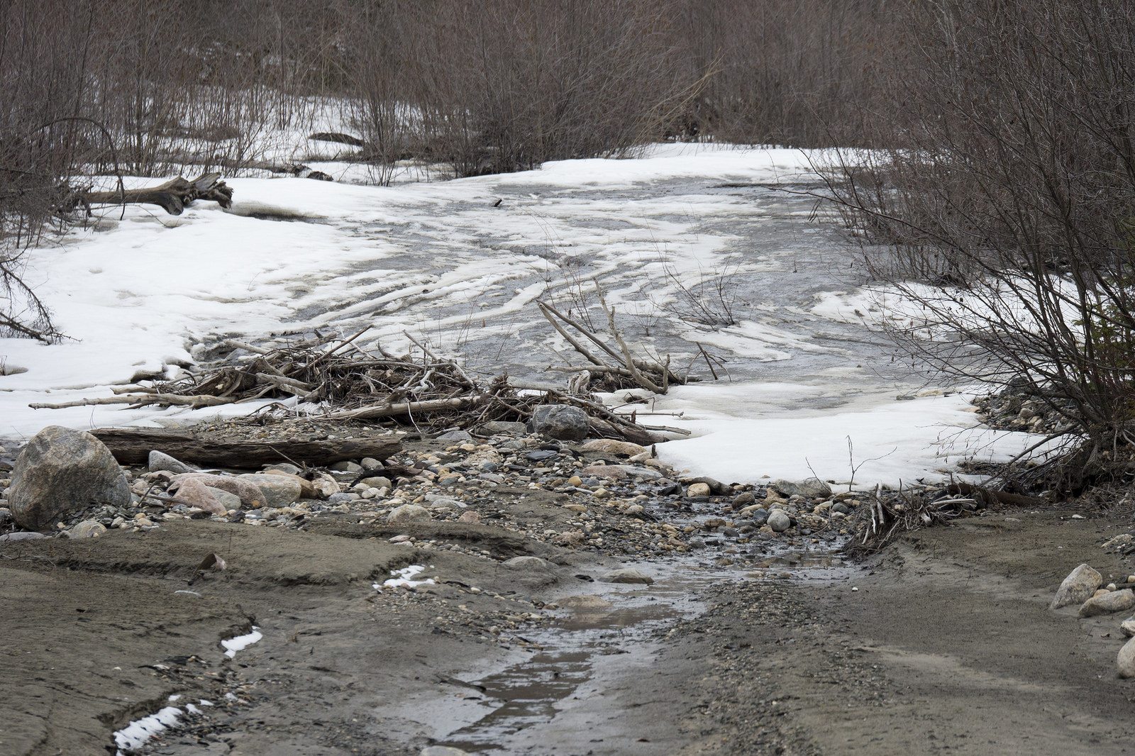
Frozen river section (Goodson)

Steve and I walking on a frozen river section (Hootz)
Steve had a more leisurely pace than Mitch and Sean hiking through the forest. He examined the buds on trees, listened for bird calls and tuned-in to the environment I passed over while keeping up with the group. I would try to hang back, but always found myself rushing to the next twig in the face.
By the time I caught up to Sean and Mitch, they were taking another break. "We've barely gone two kilometres," Sean said with a lackluster exhale. "Only, like, eight more to go," Mitch said, his words hanging in the air like a stale fart. Nothing reminds you of how out-of-shape you really are than hiking the woods in springtime.
"We don't have to make it to the mass wasting," Sean said. "We're here to enjoy it, not torture ourselves." I thought his surrender came too easily, but he was right. Survival sports are for masochists and TV celebrities.
The mud, ice and snow was not conducive to finding fossils, so I was determined to make it to the first major landslide before we gave up any more objectives. I hoped to find at least some evidence of the ancient bonebed upstream, if anything at all.
The next riverbend was much steeper than the last. We side-stepped over a muddy riverbank sending chunks of soil and rock into the water. No matter how sure the footing, the ground slid like butter.
"You guys are gonna like this," Sean shouted over the muddy river.

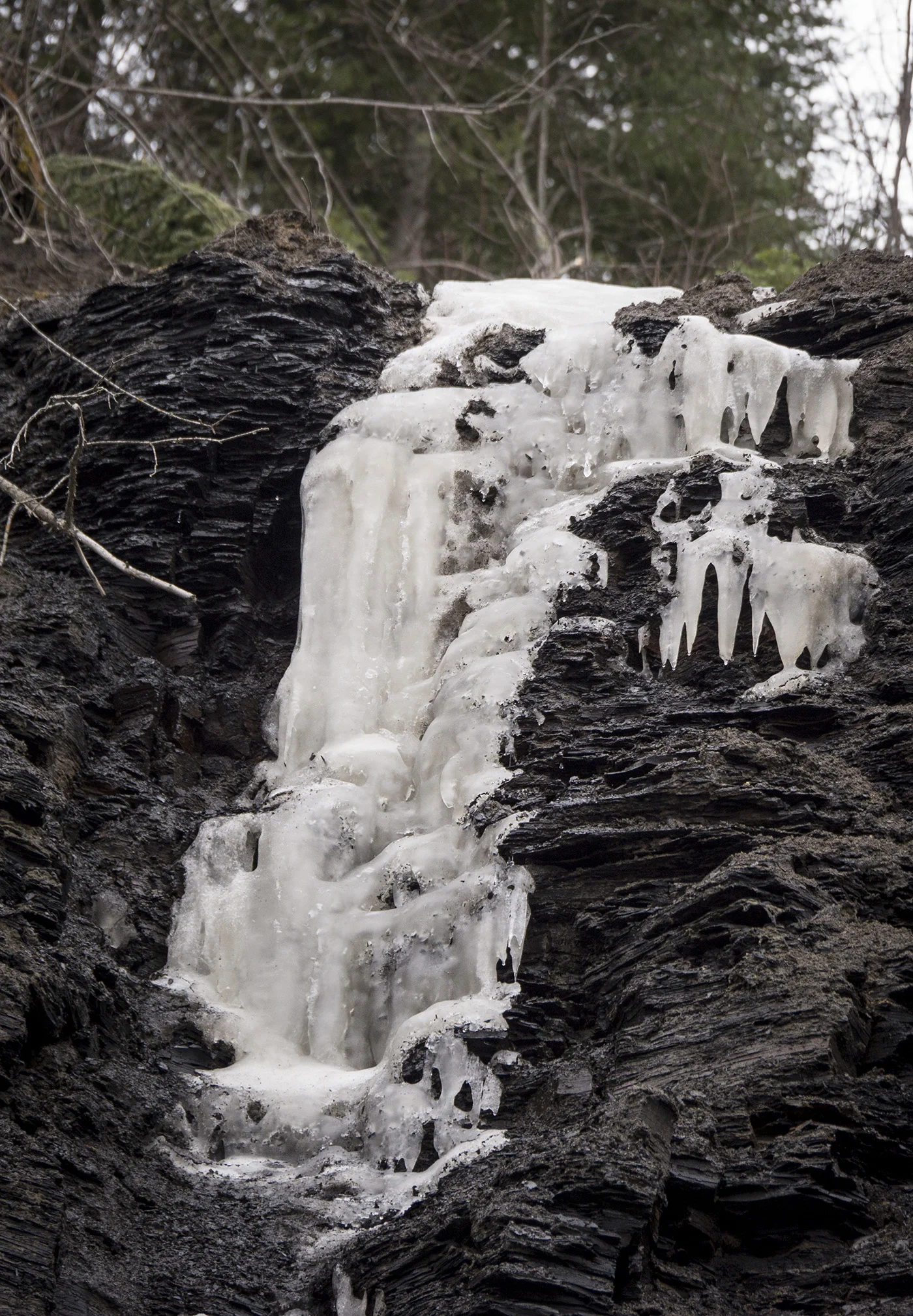
Crumbling ground and frozen cascades (Goodson)
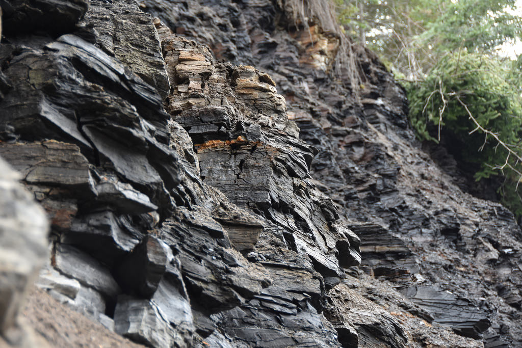
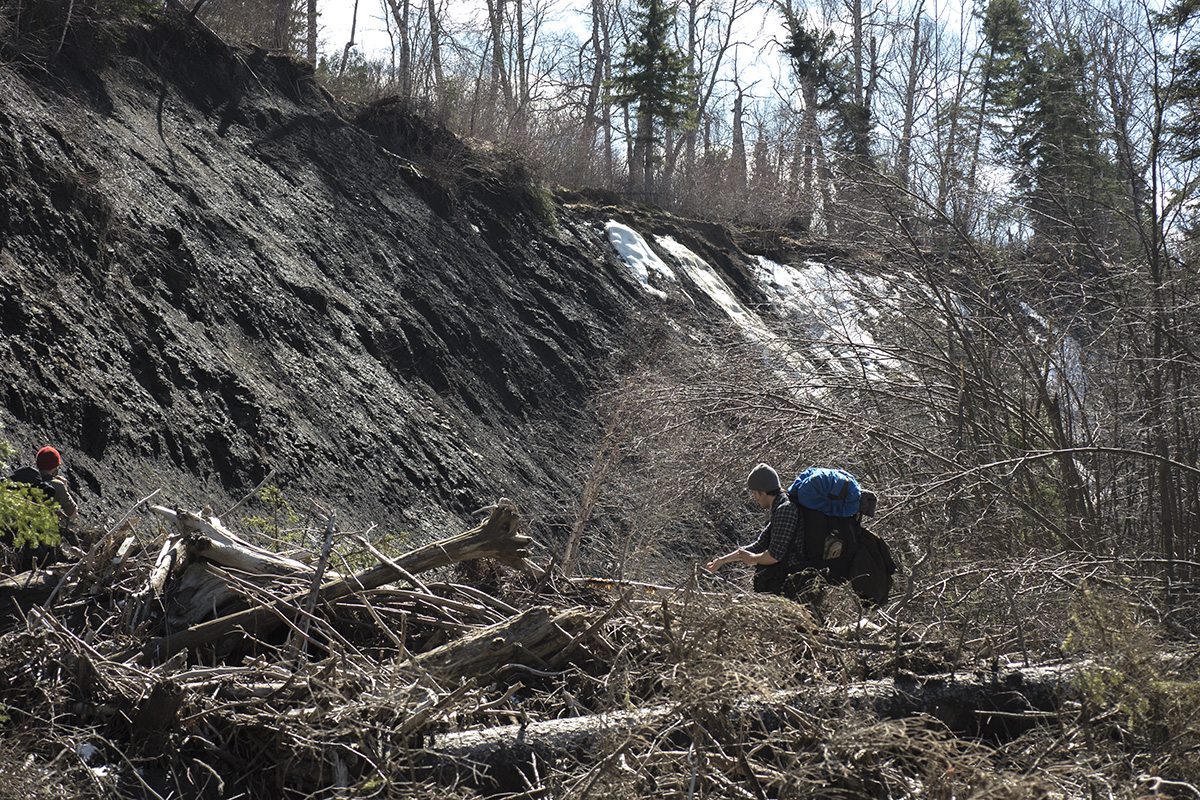
Outcrops expose the Ashville Formation, Favel Formation and Morden Shale that lie beneath the Manitoba Escarpment. (Hootz)

The Bainbridge River outcrop is the largest shale cliff we've seen to date. (Goodson)

The ivory-coloured layer is presumably bentonite, formed by volcanic ash that settled in stagnant water during the Late Cretaceous period.
The ground was crumbled shale, soft and springy to walk on. Water trickled down from the top of the cliff beneath icy cascades. Sean, who had led us to the site, was standing beneath the largest shale cliff we've seen to date.
"You smell that?" he said. "It's like walking through a tire shop."
There was an ivory-coloured strip embedded between the layers of shale. It was most likely bentonite, a rock formed by volcanic ash that settled in stagnant water during the Late Cretaceous.
We looked at the sizable cliff, while bits and pieces of shale crumbled before us and rolled downhill. "This makes me nervous," Sean said.
We descended the bank and Mitch sank into the ground to his thighs. We were walking on a thin layer of crumbled shale over two feet of snow. If the cliff weathered so quickly, I wondered how stable the ground could be elsewhere. We were in the land of landslides, after all.
The clouds revealed a clear, blue sky, and we felt good about making it at least halfway to our goal with our current pace. We decided to take lunch when I was hit with a wave of nausea. I choked down a Cliff Bar. The wrapper said nut butter with a picture of some guy on a bicycle.
We reached the next obstacle sooner than hoped — a hundred-foot vertical cliff composed of the same soft, lousy soil. It wrapped around a horseshoe bend in the river and appeared to continue farther than we could see. There was no easy way to cross the river, so I thought it would be best to bushwhack up the slope and walk the high ridge through the forest.

The skies cleared up for the afternoon (Goodson)

The Two-hundred Calorie View (Doll)
I was wrong.
Inside the bush, the slope was only slightly better than a shear cliff into the river. There was still ice on much of the ground, and where it had melted was nearly impossible to gain traction. The woods became a monster. I struggled on my knees to climb, while tangled branches clutched and pulled me back down to where I started. They whipped and scratched while I swore and yelled. One must imagine Sisyphus very much pissed-off.
I got to the top drenched in sweat, while Mitch had somehow managed to climb the summit only mildly irritated. "That was awful," he said. I gulped some scotch before getting back on my feet and mumbling something incoherent.
Mitch and I met with Steve and Sean further down the ridge. We had spent over an hour getting there and travelled less than a kilometre.
"I don't think we're going to make it," Sean said. I was too dazed to care. Mitch suggested we find camp sooner than later since rain and snow on the hike back would be a nightmare. Steve seemed cool with it all, though I suspected he was just being polite.
The woods on the ridge were worse than expected. It was thick, and had been weighed down by snow and ice over winter. This left thin, brambly bushes, all tangled with each other like a cat's cradle from hell.
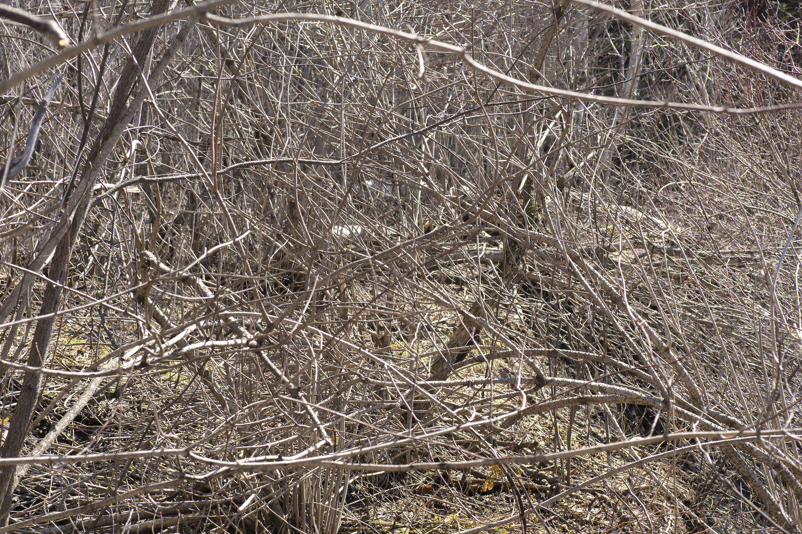
Walking through this with a backpack was one of the most frustrating hiking experiences I've had. (Goodson)

A spruce tree — split from the bottom up presumably after the ground shifted. (Goodson)
We stumbled upon a large spruce tree that had been split from the bottom to halfway up. The only reasonable explanation we could think of was the had ground shifted and tore the base of the trunk apart.
"This is why we haven't found a good place to camp yet," Sean said. "The earth is just crumbling into the river; everything looks like it was hit by a wrecking ball."
It hadn't occurred to me that we might not find somewhere to camp. There was no level ground to set up tents. There were no good trees to tie tarps. The water was undrinkable with a regular filter.
I had not hydrated well, either. I was becoming drastically weak and confused, and time was running out. There was only one patch of tall spruce trees where we might find suitable shelter. It was on the other side of the river and the only way across was by walking over thin, dead branches.
Mitch was the first to cross; I was the second.
Wood snapped as my right leg sank into the water and the weight of my backpack pressed me face-down on the bed of branches. I stayed still like a trapped animal giving up without a fight. I had no power left to figure out how to get up.
"Give me your hand," Mitch said. I passed him my camera.
The patch of spruce where we were to setup camp was a complete swamp. Even the grassy area that surrounded it was thorny and uneven. The ground was old river debris overgrown with grass – prime ankle-busting territory.
I collapsed. The sunny skies were regrettably cheerful for the dread I felt.
"Man, what are we going to do? This river is garbage," Sean said. "I can't keep going anymore."
Jean-Paul licked his bright pink paws. He no longer stood up unless he was absolutely sure we were moving.
Meanwhile, Steve filtered several litres of cold, clear meltwater he found from a small runoff creek. We drank profusely and, within minutes, new energy coursed through my veins as my brain regained its function.
"I think we need to backtrack," I suggested. There were no objections.
Water changed everything. We upped the pace and doubled back through the river searching for a place to camp. I thought we found one suitable spot among horsetails and somewhat thinner brush, until Steve pointed out that it, too, was a swamp.
By evening, we had hiked nearly the entire way back to the vehicles. There was a small clearing by the river near where we had taken our first break. This was where we would camp for the rest of the weekend.
There was little excitement for the rest of our stay. We sat through cold and rain. We tended the fire and passed time with wood-carving. On the second night, there was a spectacular display of northern lights. The auroras appeared in seconds, illuminating the entire camp with a faint radium glow, while blue-green ribbons fishtailed across the sky.
Looking through photos before I fell asleep, I could still feel the welts and scratches throbbing on my forearms as I swiped through images with undue fondness. Bainbridge River was a worthy challenge, and it beat us elegantly.
Maybe next time. (Goodson)